43 posts tagged “maps”
2024
OpenFreeMap (via) New free map tile hosting service from Zsolt Ero:
OpenFreeMap lets you display custom maps on your website and apps for free. […] Using our public instance is completely free: there are no limits on the number of map views or requests. There’s no registration, no user database, no API keys, and no cookies. We aim to cover the running costs of our public instance through donations.
The site serves static vector tiles that work with MapLibre GL. It deliberately doesn’t offer any other services such as search or routing.
From the project README looks like it’s hosted on two Hetzner machines. I don’t think the public server is behind a CDN.
Part of the trick to serving the tiles efficiently is the way it takes advantage of Btrfs:
Production-quality hosting of 300 million tiny files is hard. The average file size is just 450 byte. Dozens of tile servers have been written to tackle this problem, but they all have their limitations.
The original idea of this project is to avoid using tile servers altogether. Instead, the tiles are directly served from Btrfs partition images + hard links using an optimised nginx config.
The self-hosting guide describes the scripts that are provided for downloading their pre-built tiles (needing a fresh Ubuntu server with 300GB of SSD and 4GB of RAM) or building the tiles yourself using Planetiler (needs 500GB of disk and 64GB of RAM).
Getting started is delightfully straightforward:
const map = new maplibregl.Map({
  style: 'https://tiles.openfreemap.org/styles/liberty',
  center: [13.388, 52.517],
  zoom: 9.5,
  container: 'map',
})
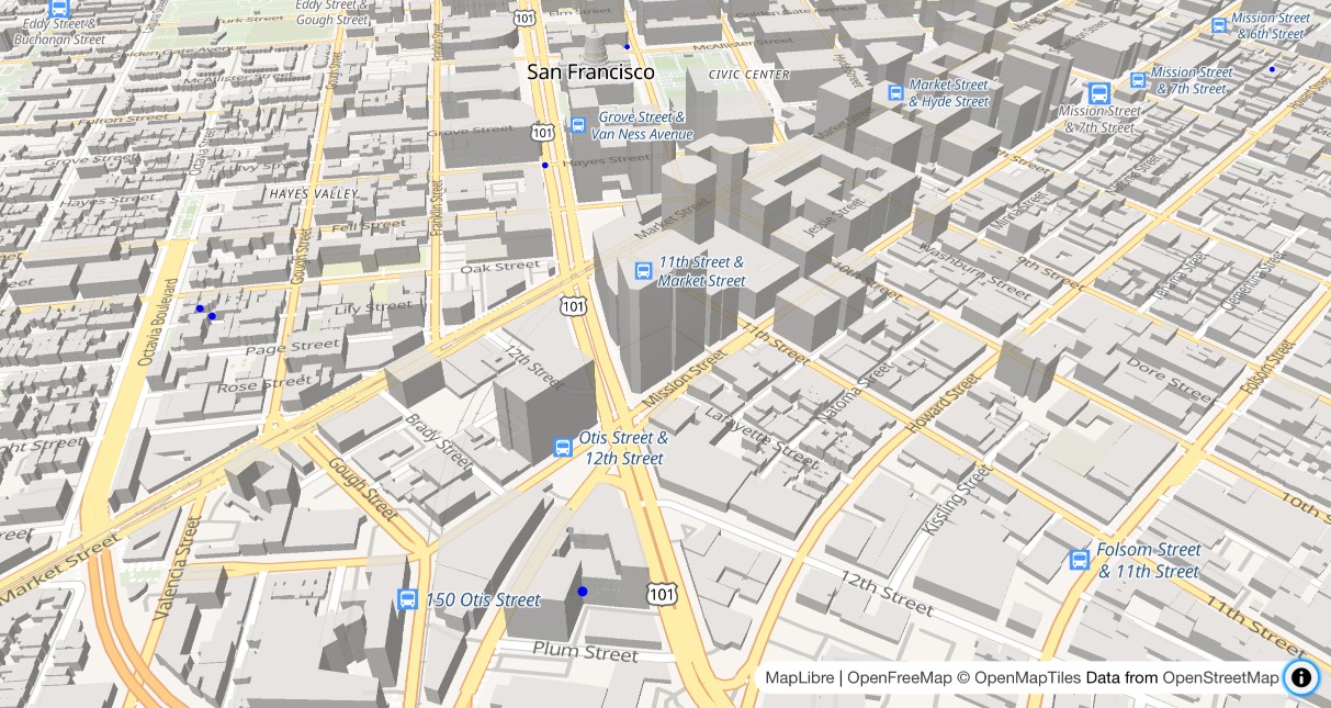
I got Claude to help build this demo showing a thousand random markers dotted around San Francisco. The 3D tiles even include building shapes!
Zsolt built OpenFreeMap based on his experience running MapHub over the last 9 years. Here’s a 2018 interview about that project.
It’s pretty incredible that the OpenStreetMap and open geospatial stack has evolved to the point now where it’s economically feasible for an individual to offer a service like this. I hope this turns out to be sustainable. Hetzner charge just €1 per TB for bandwidth (S3 can cost $90/TB) which should help a lot.
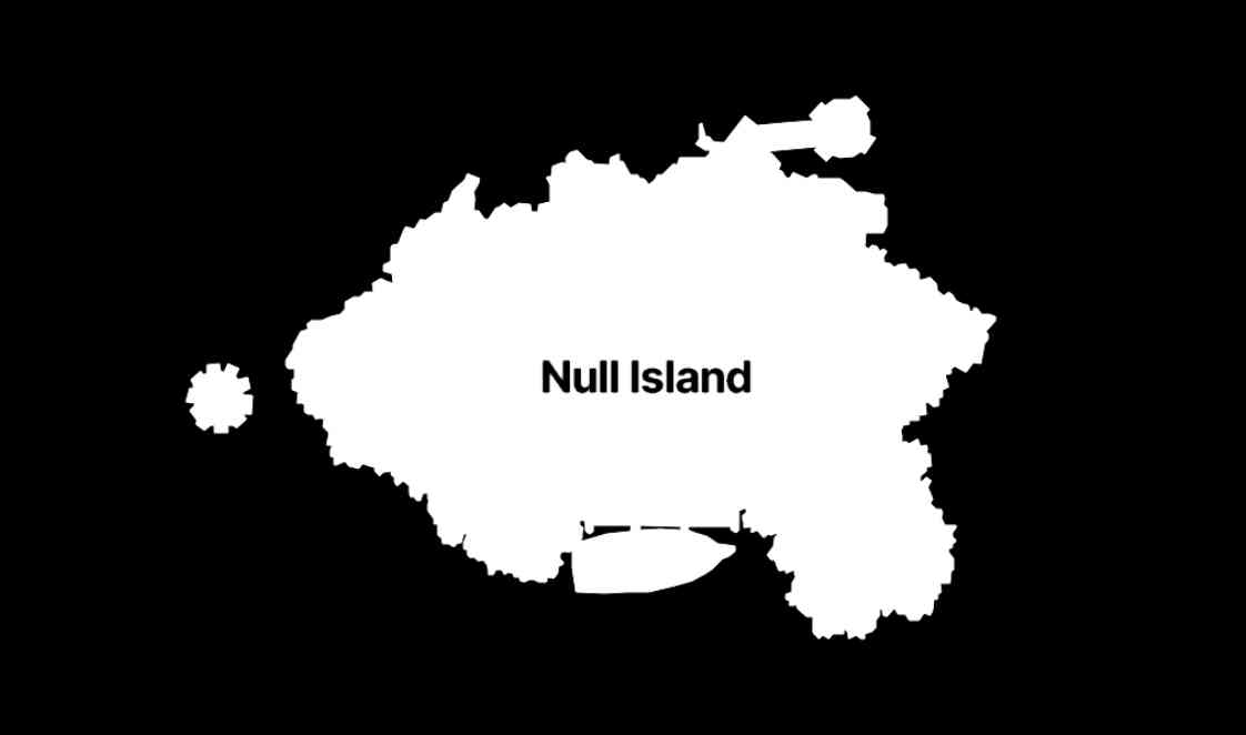
The many lives of Null Island (via) Stamen's custom basemaps have long harbored an Easter egg: zoom all the way in on 0, 0 to see the outline of the mystical "null island", the place where GIS glitches and data bugs accumulate, in the Gulf of Guinea south of Ghana.
Stamen's Alan McConchie provides a detailed history of the Easter egg - first introduced by Mike Migurski in 2010 - along with a definitive guide to the GIS jokes and traditions that surround it.
Here's Null Island on Stamen's Toner map. The shape (also available as GeoJSON) is an homage to the island from 1993's Myst, hence the outline of a large docked ship at the bottom.
Alan recently gave a talk about Stamen's updated custom maps at State of the Map US 2024 (video, slides) - their Toner and Terrain maps are now available as vector tiles served by Stadia Maps (here's the announcement), but their iconic watercolor style is yet to be updated to vectors, due to the weird array of raster tricks it used to achieve the effect.
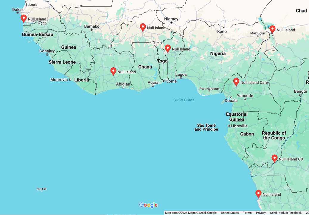
In researching this post I searched for null island on Google Maps and was delighted to learn that a bunch of entrepreneurs in Western Africa have tapped into the meme for their own businesses:
How to make self-hosted maps that work everywhere and cost next to nothing. Chris Amico provides a detailed roundup of the state of web mapping in 2024. It’s never been easier to entirely host your own mapping infrastructure, thanks to OpenStreetMap, Overture, MBTiles, PMTiles, Maplibre and a whole ecosystem of other fine open source projects.
I like Protomaps creator Brandon Liu’s description of this: “post-scarcity web mapping”.
2023
How The Post is replacing Mapbox with open source solutions (via) Kevin Schaul describes the Washington Post’s emerging open source GIS stack: OpenMapTiles, Maputnik, PMTiles and Maplibre-gl-js.
2022
A tiny web app to create images from OpenStreetMap maps
Earlier today I found myself wanting to programmatically generate some images of maps.
[... 1,388 words]2018
Apple’s New Map (via) Map nerds rejoice! Justin O’Beirne had written another spectacularly illustrated essay about web cartography, this time examining the iOS 12 upgrade to Apple Maps in most of California and a little bit of Nevada.
Datasette plugins, and building a clustered map visualization
Datasette now supports plugins!
[... 751 words]2013
Is there an open source (or freely accessible) database of geofence coordinates for common places, such as cities or national parks?
Take a look at Flickr’s openly licensed shapefiles:
[... 59 words]Does the Google Maps API let you remove details of the map such as street names to focus on pins on the map?
Yes—you can do this with map styles (which allow you to set the visibility if road labels, among other things): http://developers.google.com/map...
[... 53 words]2009
Cartographer.js. “Thematic mapping for Google Maps”—which means an easy way of adding heat maps (aka chloropleths), pie charts and point clusters as a layer over a Google map.
Best of OpenStreetMap (via) I keep on telling people OpenStreetMap is this year’s Wikipedia—at its best, it beats commercially available maps. This “best of” site highlights the areas where OSM really shines (the yellow stars)—the German mapping community in particular have produced some outstanding cartography.
Making Image Overlays Easy with GGroundOverlay and GGeoXML (via) Surprisingly, there doesn’t appear to be a good online tool for helping align an overlay image with a Google Map and exporting the result as a KML file. This is the best I could find—Yahoo! used to have a tool called MapMixer but it doesn’t seem to exist any more.
Flickr Shapefiles Public Dataset 1.0. Another awesome Geo dataset from the Yahoo! stable—this time it’s Flickr releasing shapefiles (geometrical shapes) for hundreds of thousands of places around the world, under the CC0 license which makes them essentially public domain. The shapes themselves have been crowdsourced from geocoded photos uploaded to Flickr, where users can “correct” the textual location assigned to each photo. Combine this with the GeoPlanet WOE data and you get a huge, free dataset describing the human geography of the world.
UK Television Series Map. Inspired by the US sitcom map, Meg Pickard is plotting TV series on a map of the UK.
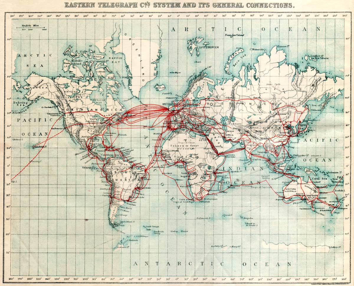
1901EasternTelegraph.jpg (via) A map of undersea telegraph cables as of 1901.
Travel time to major cities: A global map of Accessibility (via) Visualisation developed by the European Commission and the World Bank.
2008
Motorway map of England, Scotland and Wales (via) In the style of Harry Beck’s London Tube map.
Noncontiguous area cartograms. a.k.a. really funky data visualisation maps. Includes lots of examples, plus ActionScript 3 source code.
Live Piracy Map. That’s a heck of a lot of (real, nasty, sea-faring) pirates.
FOWA London—Beyond GoogleMaps. Andrew Turner’s talk at FOWA was the most information dense presentation I’ve ever seen, and discussed a huge number of cool geo projects that I’d never previously heard of. Andrew links to the full slides and video, well worth a watch.
Places to see in London (for geeks). My geek-oriented guide to London attractions that you may not hear about otherwise, updated for this year’s overseas FOWA attendees. Suggestions for additions welcome.
Ordnance Survey OpenSpace Demo (via) Niall Kennedy threw a demo up on his site—the map seems to load a lot faster than Google Maps and the level of detail once you zoom down to street level is really impressive.
OS OpenSpace from Ordnance Survey (via) Ordinance Survey now provide a free JavaScript mapping API for “non-commercial purposes” by “private individuals”. The maps look incredibly detailed, although I can’t find any live API demos on the site (the documentation is illustrated with screenshots).
OSM Super-Strength Export. Awesome new feature on OpenStreetMap: you can browse to anywhere on the map, then hit “export” and download a rendered bitmap or vector (PDF and SVG) image of the currently displayed map—and because it’s OSM there’s no watermark and a very liberal usage license.
KML: A new standard for sharing maps. Google’s KML format, which is already supported by both Microsoft and Yahoo!’s map software, has been accepted under the wing of the Open Geospatial Consortium and is now an international standard.
A List Apart: Issue 256. The EveryBlock issue. Paul Smith on EveryBlock’s tasty custom maps, and Wilson Miner on EveryBlock’s tasty accessible data charts.
London Connections. Marvellously obsessive blog about the vagaries of London transport, including some really nice custom created maps. I love detailed maps of tube stations; anyone know a good place to find them?
Google Maps Clusterer. I’ve looked at a few clustering libraries for Google Maps, but this one seems to have the nicest API.
2007
Information Freeway (via) Really lovely interface to Open Street Map, sadly suffering from a horribly vague name and almost no publicity at all.
Get Lat Lon. I finally got fed up of hunting around for simple latitude/longitude tools when messing around with mapping APIs, so I built my own with a memorable URL. I plan to add new features as and when I need them.