54 posts tagged “mapping”
2024
OpenStreetMap vector tiles demo
(via)
Long-time OpenStreetMap developer Paul Norman has been working on adding vector tile support to OpenStreetMap for quite a while. Paul recently announced that vector.openstreetmap.org is now serving vector tiles (in Mapbox Vector Tiles (MVT) format) - here's his interactive demo for seeing what they look like.
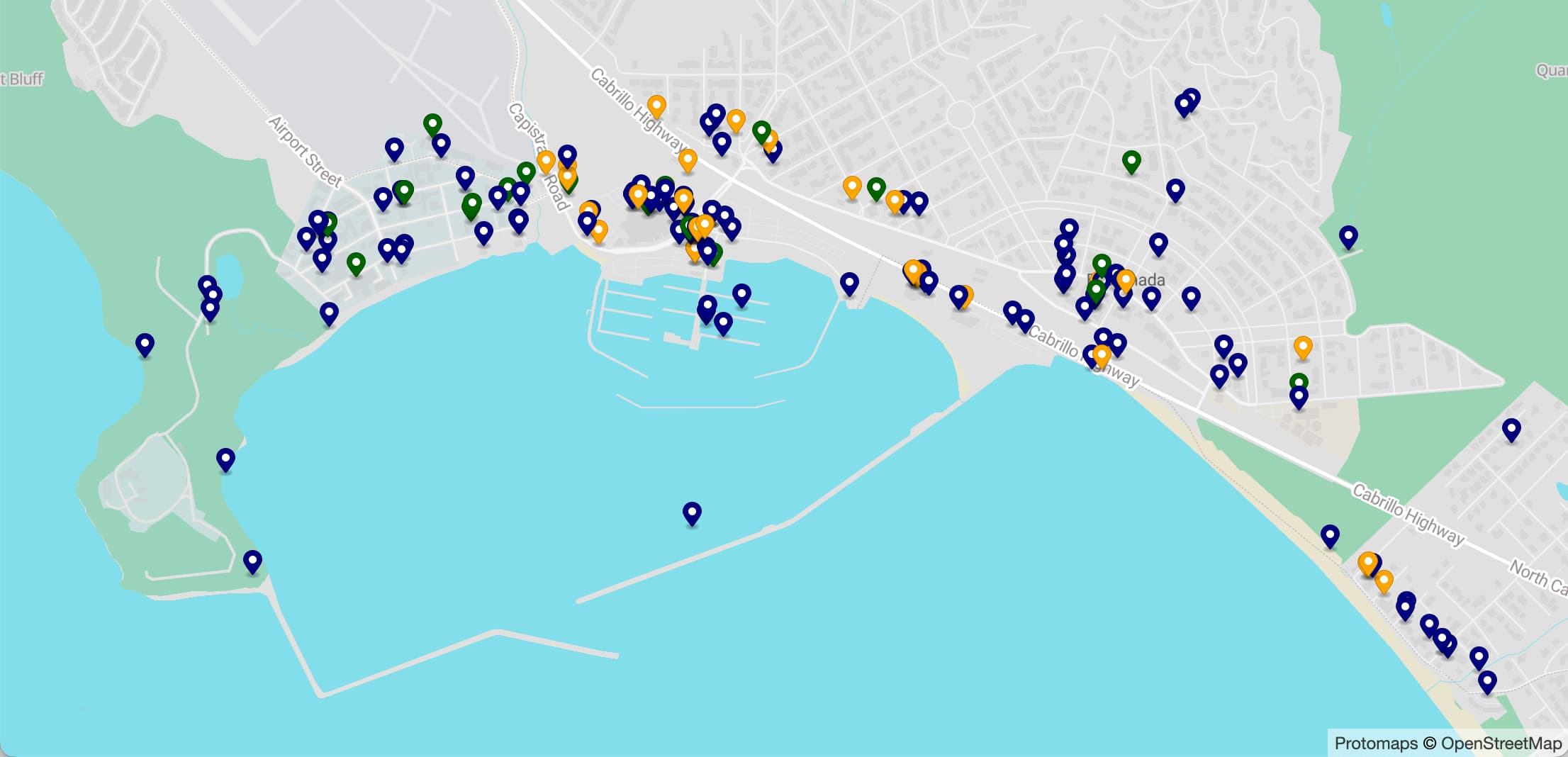
Visualizing local election results with Datasette, Observable and MapLibre GL
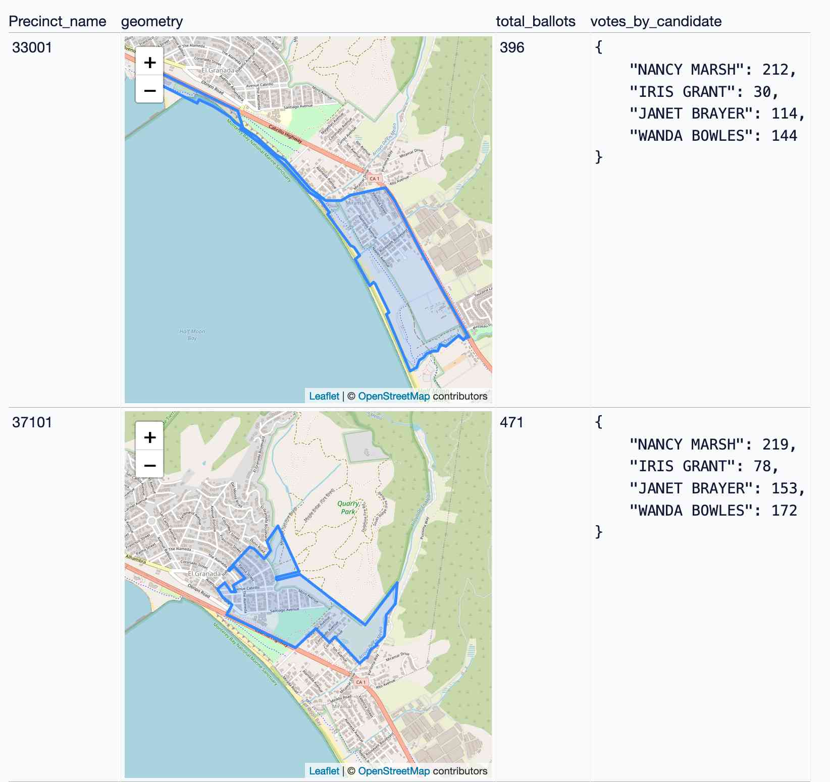
Alex Garcia and myself hosted the first Datasette Open Office Hours on Friday—a live-streamed video session where we hacked on a project together and took questions and tips from community members on Discord.
[... 3,390 words]tiny-world-map (via) I love this project. It’s a JavaScript file (694K uncompressed, 283KB compressed) which can be used with the Leaflet mapping library and provides a SVG base map of the world with country borders and labels for every world city with a population more than 48,000—10,000 cities total.
This means you can bundle an offline map of the world as part of any application that doesn’t need a higher level of detail. A lot of smaller island nations are missing entirely though, so this may not be right for every project.
It even includes a service worker to help implement offline mapping support, plus several variants of the map with less cities that are even smaller.
2023
DALL-E 3, GPT4All, PMTiles, sqlite-migrate, datasette-edit-schema
I wrote a lot this week. I also did some fun research into new options for self-hosting vector maps and pushed out several new releases of plugins.
[... 1,362 words]2022
GPSJam (via) John Wiseman’s “Daily maps of GPS interference” —a beautiful interactive globe (powered by Mapbox GL) which you can use to see points of heaviest GPS interference over a 24 hour period, using data collected from commercial airline radios by ADS-B Exchange. “From what I can tell the most common reason for aircraft GPS systems to have degraded accuracy is jamming by military systems. At least, the vast majority of aircraft that I see with bad GPS accuracy are flying near conflict zones where GPS jamming is known to occur.”
2021
Serving map tiles from SQLite with MBTiles and datasette-tiles
Working on datasette-leaflet last week re-kindled my interest in using Datasette as a GIS (Geographic Information System) platform. SQLite already has strong GIS functionality in the form of SpatiaLite and datasette-cluster-map is currently the most downloaded plugin. Most importantly, maps are fun!
[... 1,334 words]2010
Polymaps. Absurdly classy: “a JavaScript library for image- and vector-tiled maps using SVG”. It can pull in image tiles from sources such as OpenStreetMap, then overlay SVG paths specified using GeoJSON. The demos make use of GeoJSON tiles for US states and counties hosted on AppEngine. The library is developed by Stamen and SimpleGeo, and released under a BSD license. SVG support in the browser is required.
MapOSMatic. Clever service built on top of OpenStreetMap, which renders double sided city maps with a map and grid on one size and an A-Z street name index on the other. Runs on top of Mapnik, PostGIS and Cairo, with a few thousand additional lines of Python and Django.
Doing things with Ordnance Survey OpenData. Jo Walsh’s guide to processing Ordnance Survey OpenData using PostgreSQL and PostGIS.
ClearMaps: A Mapping Framework for Data Visualization. An open source library for map visualisations using ActionScript, with an Adobe AIR based encoding tool for translating data from shapefiles in to vector data suitable for use with the library.
OSM the default map in Haiti. A search and rescue team member in Haiti sends word that digital maps constructed by the OpenStreetMap community are spreading by word of mouth and being loaded on to GPS units on the ground.
2009
The View from Above. Andy Allan’s notes on three different projects that aerial imagery with OpenStreetMap. Andy and friends hired a small plane and took their own aerial photographs of Stratford-upon-Avon as a demo for a GIS conference. Aid agencies in the Philippines benefitted from OSM and a donation of high quality satellite imagery. Rural Georgia now has hiqh quality images from 2007 thanks to the Department of Agriculture.
GeoPlanet data available again (via) Good news: the Yahoo! GeoPlanet data dump is available again. An issue with one of their data providers meant they had to remove that supplier’s data from the dump, but it’s now been separated and the dataset is live gain. By the end of 2010 they intend to derive all of the data from completely open sources.
About 80 per cent of public sector data mentions a place. Making Ordnance Survey data more freely available will encourage more effective exploitation of public data by businesses, individuals and community organisations.
— Stephen Timms, Minister for Digital Britain
Re-mapping the future for Ordnance Survey—making public data public. “The Prime Minister and Communities Secretary John Denham will today announce that the public will have more access to Ordnance Survey maps from next year, as part of a Government drive to open up data to improve transparency.”
A set of geodata, or a map, is libre only if somebody can give you a cake with that map on top, as a present.
How to Make a US County Thematic Map Using Free Tools. This is the trick I’ve been using to generate choropleths at the Guardian for the past year: figure out the preferred colours for a set of data in a Python script and then rewrite an SVG file to colour in the areas. I use ElementTree rather than BeautifulSoup but the technique is exactly the same. The best thing about SVG is that our graphics department can export them directly out of Illustrator, with named layers and paths automatically becoming SVG ID attributes. Bonus tip: sometimes you don’t have to rewrite the SVG XML at all, instead you can generate CSS to colour areas by ID selector and inject it in to the top of the file.
Cartographer.js. “Thematic mapping for Google Maps”—which means an easy way of adding heat maps (aka chloropleths), pie charts and point clusters as a layer over a Google map.
Temporary Mapping: Solar Decathlon. The OpenStreetMap default renderer supports start_date and end_date tags, meaning you can map temporary installations (in this case the 2009 Solar Decathlon on the DC National Mall) and have them automatically appear and disappear at the correct times.
OSM static map api. A very welcome addition to the OpenStreetMap world (with plenty of options for overlaying points, polygons etc) slightly marred by the size and relative ugliness of the OpenStreetMap watermark.
OpenStreetMap Rendering Database. Amazon have added an OpenStreetMap snapshot as a public data set, thanks to some smart prompting by Jeremy Dunck.
openstreetmap genuine advantage. The OpenStreetMap data model (points, ways and relations, all allowing arbitrary key/value tags) is a real thing of beauty—simple to understand but almost infinitely extensible. Mike Migurski’s latest project adds PGP signing to OpenStreetMap, allowing organisations (such as local government) to add a signature to a way (a sequence of points) and a subset of its tags, then write that signature in to a new tag on the object.
Tile Drawer (via) The most inspired use of EC2 I’ve seen yet: center a map on an area, pick a Cascadenik stylesheet URL (or write and link to your own) and Tile Drawer gives you an Amazon EC2 AMI and a short JSON snippet. Launch the AMI with the JSON as the “user data” parameter and you get your own OpenStreetMap tile rendering server, which self-configures on startup and starts rendering and serving tiles using your custom design.
Static Maps API v2. The new version of the Google Static Maps API (static images generated using arguments in a URL, no JavaScript required) adds support for paths, areas and automatically geocoding addresses to specify locations of markers and the centre of the map.
Best of OpenStreetMap (via) I keep on telling people OpenStreetMap is this year’s Wikipedia—at its best, it beats commercially available maps. This “best of” site highlights the areas where OSM really shines (the yellow stars)—the German mapping community in particular have produced some outstanding cartography.
Hack Day tools for non-developers
We’re about to run our second internal hack day at the Guardian. The first was an enormous amount of fun and the second one looks set to be even more productive.
[... 920 words]walking papers lives. Round trip mapping: print out a map from OpenStreetMap, walk around annotating it with a pen, then scan the result back in (a QR code ensures the area and orientation is recognised) . Specifically targeted at eye-level stuff which can’t be collected using GPS or aerial imagery alone. When I grow up, I want to be Mike Migurski.
Mapstraction API Sandbox. Andrew Turner’s new tool for exploring the Mapstraction JavaScript library, which provides a unified code interface to 12 different mapping services
Announcing Google Maps API v3. Sounds like a complete rewrite, with performance as the key goal. Only a developer preview at the moment, but my favourite feature is that API keys are no longer required.
slippy faumaxion, take two. Mike Migurski made a slippy map using triangular tiles, based on the same principle as Buckminster Fuller’s famous Dymaxion World Map.