55 posts tagged “openstreetmap”
2026
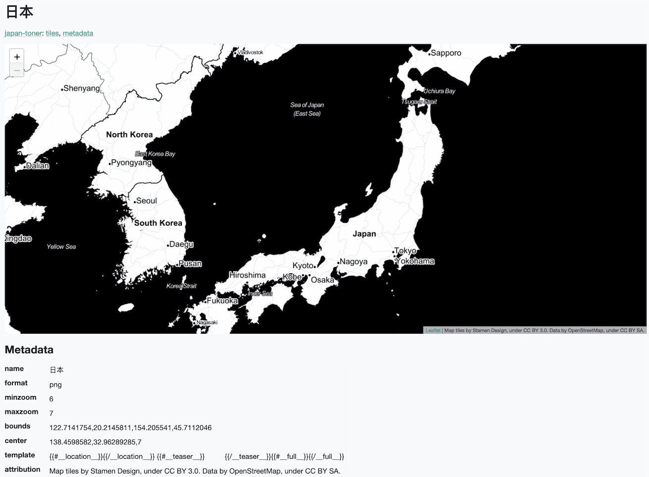
The OpenStreetMap tiles on the Datasette global-power-plants demo weren't displaying correctly. This turned out to be caused by two bugs.
The first is that the CAPTCHA I added to that site a few weeks ago was triggering for the .json fetch requests used by the map plugin, and since those weren't HTML the user was not being asked to solve them. Here's the fix.
The second was that OpenStreetMap quite reasonably block tile requests from sites that use a Referrer-Policy: no-referrer header.
Datasette does this by default, and I didn't want to change that default on people without warning - so I had Codex + GPT-5.5 build me a new plugin to help set that header to another value.
2025
OpenTimes (via) Spectacular new open geospatial project by Dan Snow:
OpenTimes is a database of pre-computed, point-to-point travel times between United States Census geographies. It lets you download bulk travel time data for free and with no limits.
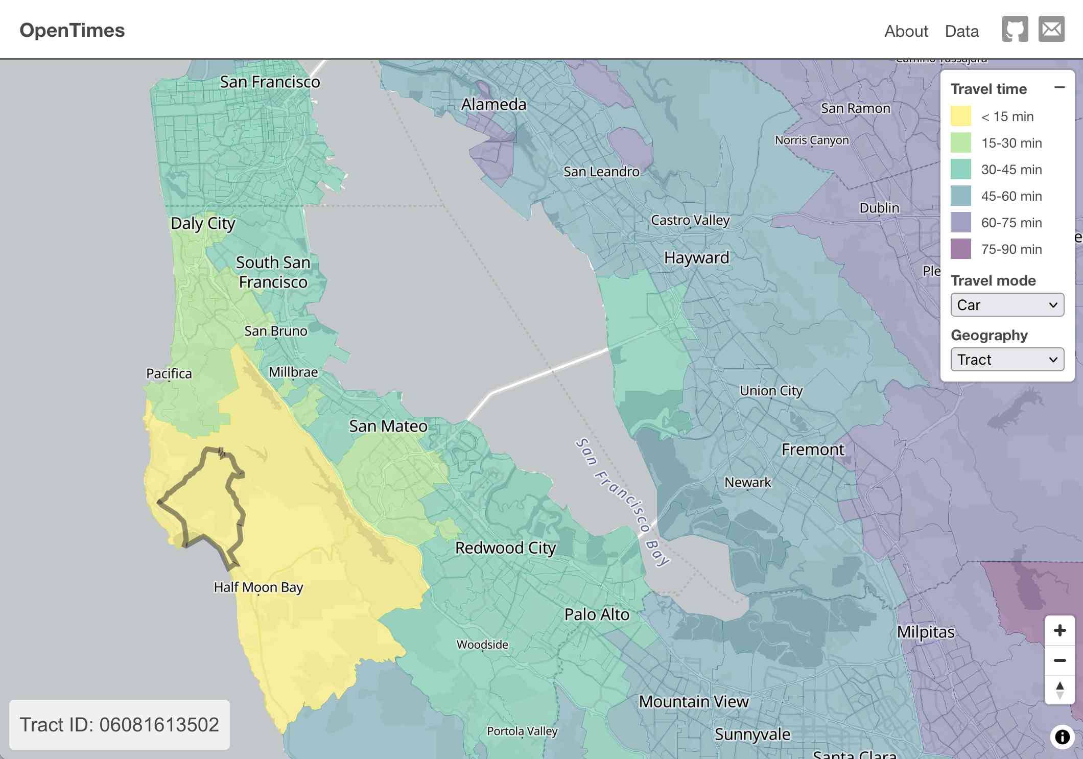
Here's what I get for travel times by car from El Granada, California:
The technical details are fascinating:
- The entire OpenTimes backend is just static Parquet files on Cloudflare's R2. There's no RDBMS or running service, just files and a CDN. The whole thing costs about $10/month to host and costs nothing to serve. In my opinion, this is a great way to serve infrequently updated, large public datasets at low cost (as long as you partition the files correctly).
Sure enough, R2 pricing charges "based on the total volume of data stored" - $0.015 / GB-month for standard storage, then $0.36 / million requests for "Class B" operations which include reads. They charge nothing for outbound bandwidth.
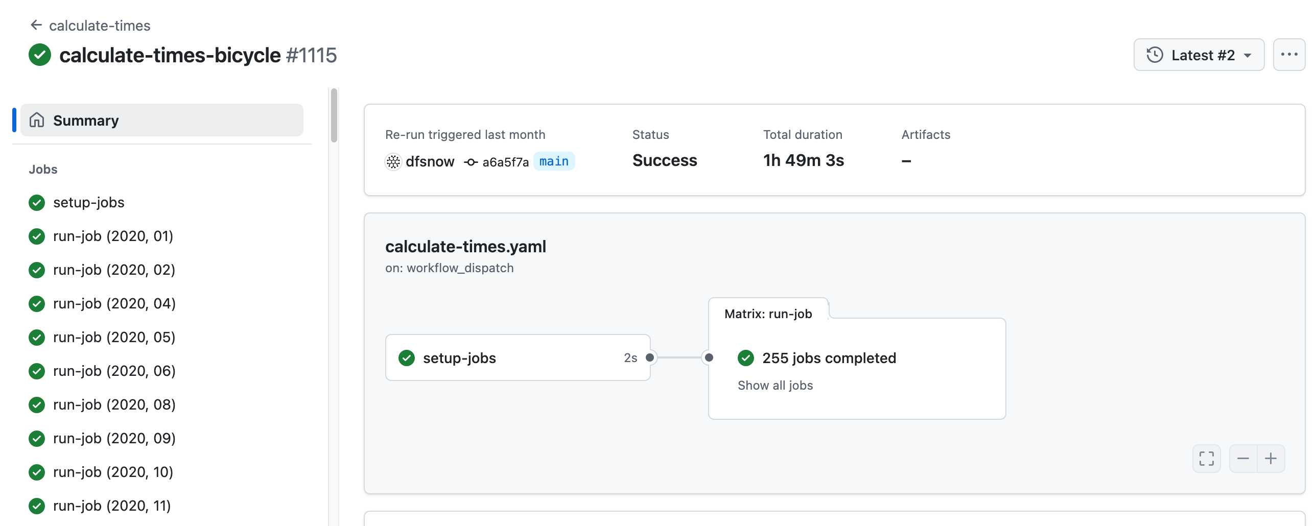
- All travel times were calculated by pre-building the inputs (OSM, OSRM networks) and then distributing the compute over hundreds of GitHub Actions jobs. This worked shockingly well for this specific workload (and was also completely free).
Here's a GitHub Actions run of the calculate-times.yaml workflow which uses a matrix to run 255 jobs!
Relevant YAML:
  matrix:
    year: ${{ fromJSON(needs.setup-jobs.outputs.years) }}
    state: ${{ fromJSON(needs.setup-jobs.outputs.states) }}
Where those JSON files were created by the previous step, which reads in the year and state values from this params.yaml file.
- The query layer uses a single DuckDB database file with views that point to static Parquet files via HTTP. This lets you query a table with hundreds of billions of records after downloading just the ~5MB pointer file.
This is a really creative use of DuckDB's feature that lets you run queries against large data from a laptop using HTTP range queries to avoid downloading the whole thing.
The README shows how to use that from R and Python - I got this working in the duckdb client (brew install duckdb):
INSTALL httpfs;
LOAD httpfs;
ATTACH 'https://data.opentimes.org/databases/0.0.1.duckdb' AS opentimes;

SELECT origin_id, destination_id, duration_sec
  FROM opentimes.public.times
  WHERE version = '0.0.1'
      AND mode = 'car'
      AND year = '2024'
      AND geography = 'tract'
      AND state = '17'
      AND origin_id LIKE '17031%' limit 10;
In answer to a question about adding public transit times Dan said:
In the next year or so maybe. The biggest obstacles to adding public transit are:
- Collecting all the necessary scheduling data (e.g. GTFS feeds) for every transit system in the county. Not insurmountable since there are services that do this currently.
- Finding a routing engine that can compute nation-scale travel time matrices quickly. Currently, the two fastest open-source engines I've tried (OSRM and Valhalla) don't support public transit for matrix calculations and the engines that do support public transit (R5, OpenTripPlanner, etc.) are too slow.
GTFS is a popular CSV-based format for sharing transit schedules - here's an official list of available feed directories.
This whole project feels to me like a great example of the baked data architectural pattern in action.
2024
OpenStreetMap embed URL.
I just found out OpenStreetMap have a "share" button which produces HTML for an iframe targetting https://www.openstreetmap.org/export/embed.html, making it easy to drop an OpenStreetMap map onto any web page that allows iframes.
As far as I can tell the supported parameters are:
bbox=then min longitude, min latitude, max longitude, max latitudemarker=optional latitude, longitude coordinate for a marker (only a single marker is supported)layer=mapnik- other values I've found that work arecyclosm,cyclemap,transportmapandhot(for humanitarian)
Here's HTML for embedding this on a page using a sandboxed iframe - the allow-scripts is necessary for the map to display.
<iframe
sandbox="allow-scripts"
style="border: none; width: 100%; height: 20em;"
src="https://www.openstreetmap.org/export/embed.html?bbox=-122.613%2C37.431%2C-122.382%2C37.559&layer=mapnik&marker=37.495%2C-122.497"
></iframe>
Thanks to this post I learned that iframes are rendered correctly in NetNewsWire, NewsExplorer, NewsBlur and Feedly on Android.
OpenStreetMap vector tiles demo
(via)
Long-time OpenStreetMap developer Paul Norman has been working on adding vector tile support to OpenStreetMap for quite a while. Paul recently announced that vector.openstreetmap.org is now serving vector tiles (in Mapbox Vector Tiles (MVT) format) - here's his interactive demo for seeing what they look like.
OpenFreeMap (via) New free map tile hosting service from Zsolt Ero:
OpenFreeMap lets you display custom maps on your website and apps for free. […] Using our public instance is completely free: there are no limits on the number of map views or requests. There’s no registration, no user database, no API keys, and no cookies. We aim to cover the running costs of our public instance through donations.
The site serves static vector tiles that work with MapLibre GL. It deliberately doesn’t offer any other services such as search or routing.
From the project README looks like it’s hosted on two Hetzner machines. I don’t think the public server is behind a CDN.
Part of the trick to serving the tiles efficiently is the way it takes advantage of Btrfs:
Production-quality hosting of 300 million tiny files is hard. The average file size is just 450 byte. Dozens of tile servers have been written to tackle this problem, but they all have their limitations.
The original idea of this project is to avoid using tile servers altogether. Instead, the tiles are directly served from Btrfs partition images + hard links using an optimised nginx config.
The self-hosting guide describes the scripts that are provided for downloading their pre-built tiles (needing a fresh Ubuntu server with 300GB of SSD and 4GB of RAM) or building the tiles yourself using Planetiler (needs 500GB of disk and 64GB of RAM).
Getting started is delightfully straightforward:
const map = new maplibregl.Map({
  style: 'https://tiles.openfreemap.org/styles/liberty',
  center: [13.388, 52.517],
  zoom: 9.5,
  container: 'map',
})
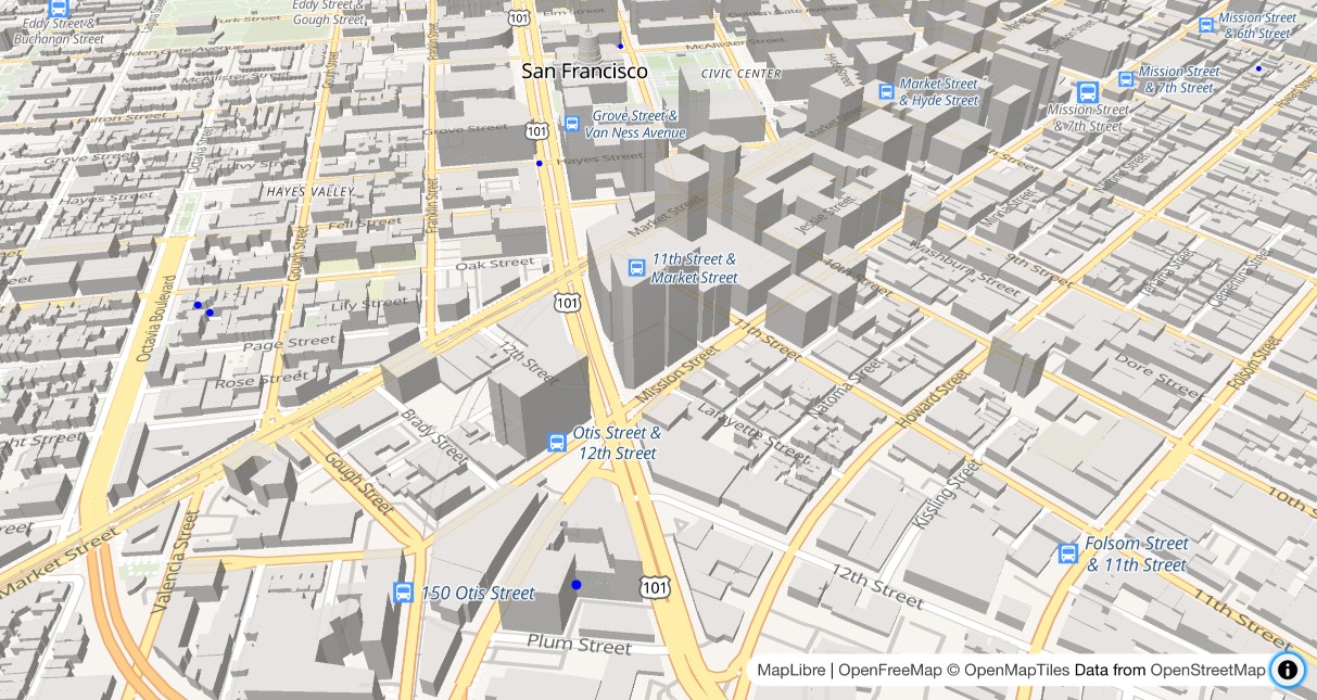
I got Claude to help build this demo showing a thousand random markers dotted around San Francisco. The 3D tiles even include building shapes!
Zsolt built OpenFreeMap based on his experience running MapHub over the last 9 years. Here’s a 2018 interview about that project.
It’s pretty incredible that the OpenStreetMap and open geospatial stack has evolved to the point now where it’s economically feasible for an individual to offer a service like this. I hope this turns out to be sustainable. Hetzner charge just €1 per TB for bandwidth (S3 can cost $90/TB) which should help a lot.
Optimizing Large-Scale OpenStreetMap Data with SQLite (via) JT Archie describes his project to take 9GB of compressed OpenStreetMap protobufs data for the whole of the United States and load it into a queryable SQLite database.
OSM tags are key/value pairs. The trick used here for FTS-accelerated tag queries is really neat: build a SQLite FTS table containing the key/value pairs as space concatenated text, then run queries that look like this:
SELECT
    id
FROM
    entries e
    JOIN search s ON s.rowid = e.id
WHERE
    -- use FTS index to find subset of possible results
    search MATCH 'amenity cafe'
    -- use the subset to find exact matches
    AND tags->>'amenity' = 'cafe';
JT ended up building a custom SQLite Go extension, SQLiteZSTD, to further accelerate things by supporting queries against read-only zstd compresses SQLite files. Apparently zstd has a feature that allows "compressed data to be stored so that subranges of the data can be efficiently decompressed without requiring the entire document to be decompressed", which works well with SQLite's page format.
How to make self-hosted maps that work everywhere and cost next to nothing. Chris Amico provides a detailed roundup of the state of web mapping in 2024. It’s never been easier to entirely host your own mapping infrastructure, thanks to OpenStreetMap, Overture, MBTiles, PMTiles, Maplibre and a whole ecosystem of other fine open source projects.
I like Protomaps creator Brandon Liu’s description of this: “post-scarcity web mapping”.
2023
How The Post is replacing Mapbox with open source solutions (via) Kevin Schaul describes the Washington Post’s emerging open source GIS stack: OpenMapTiles, Maputnik, PMTiles and Maplibre-gl-js.
2022
A tiny web app to create images from OpenStreetMap maps
Earlier today I found myself wanting to programmatically generate some images of maps.
[... 1,388 words]2021
Weeknotes: Mostly messing around with map tiles
Most of what I worked on this week was covered in Serving map tiles from SQLite with MBTiles and datasette-tiles. I built two new plugins: datasette-tiles for serving map tiles, and datasette-basemap which bundles map tiles for zoom levels 0-6 of OpenStreetMap. I also released download-tiles for downloading tiles and bundling them into an MBTiles database.
[... 350 words]Serving map tiles from SQLite with MBTiles and datasette-tiles
Working on datasette-leaflet last week re-kindled my interest in using Datasette as a GIS (Geographic Information System) platform. SQLite already has strong GIS functionality in the form of SpatiaLite and datasette-cluster-map is currently the most downloaded plugin. Most importantly, maps are fun!
[... 1,334 words]2020
The open secret Jennings filled me in on is that OpenStreetMap (OSM) is now at the center of an unholy alliance of the world’s largest and wealthiest technology companies. The most valuable companies in the world are treating OSM as critical infrastructure for some of the most-used software ever written. The four companies in the inner circle— Facebook, Apple, Amazon, and Microsoft— have a combined market capitalization of over six trillion dollars.
Announcing Daylight Map Distribution. Mike Migurski announces a new distribution of OpenStreetMap: a 42GB dump of the version of the data used by Facebook, carefully moderated to minimize the chance of incorrect or maliciously offensive edits. Lots of constructive conversation in the comments about the best way for Facebook to make their moderation decisions more available to the OSM community.
2018
Statistical NLP on OpenStreetMap. libpostal is ferociously clever: it’s a library for parsing and understanding worldwide addresses, built on top of a machine learning model trained on millions of addresses from OpenStreetMap. Al Barrentine describes how it works in this fascinating and detailed essay.
2017
Building a location to time zone API with SpatiaLite, OpenStreetMap and Datasette
Given a latitude and longitude, how can we tell what time zone that point lies within? Here’s how I built a simple JSON API to answer that question, using a combination of data from OpenStreetMap, the SpatiaLite extension for SQLite and my Datasette API tool.
[... 2,185 words]simonepri/geo-maps. Neat project which publishes GeoJSON maps of the world automatically derived from OpenStreetMap. Three variants are available: country political maritime boundaries, country political coastline boundaries and a general outline of the world’s land territories.
2011
We Need to Stop Google’s Exploitation of Open Communities. Mikel Maron from OpenStreetMap is justifiably angry about Google MapMaker, which copies OpenStreetMap’s model of crowdsourcing geographic data (even copying the OSM idea of Mapping Parties) but keeps the data under a much more restrictive license, and uses the Google brand to market itself to African governments.
2010
Polymaps. Absurdly classy: “a JavaScript library for image- and vector-tiled maps using SVG”. It can pull in image tiles from sources such as OpenStreetMap, then overlay SVG paths specified using GeoJSON. The demos make use of GeoJSON tiles for US states and counties hosted on AppEngine. The library is developed by Stamen and SimpleGeo, and released under a BSD license. SVG support in the browser is required.
MapOSMatic. Clever service built on top of OpenStreetMap, which renders double sided city maps with a map and grid on one size and an A-Z street name index on the other. Runs on top of Mapnik, PostGIS and Cairo, with a few thousand additional lines of Python and Django.
getlatlon.com commit dae961a... I’ve finally added an OpenStreetMap tab to getlatlon.com—here’s the diff, it turns out adding a custom OpenStreetMap layer to an existing Google Maps application only takes a few lines of boilerplate code.
Why Google MapMaker is not Open. Non-commercial use only, strict attribution requirements and you aren’t allowed to use the data for services that might compete with Google. This is why I’m disappointed every time I see Google encouraging people to contribute to Map Make, especially in the developing world—if those people contributed to OpenStreetMap instead they would be building something far more valuable for their community.
On walking into a disaster zone. Schuyler Erle: “The World Bank was looking for technical GIS professionals, ideally French-speaking, to go and advise the government [...] I can sort of speak French. Sure, why not?”
OSM the default map in Haiti. A search and rescue team member in Haiti sends word that digital maps constructed by the OpenStreetMap community are spreading by word of mouth and being loaded on to GPS units on the ground.
2009
The View from Above. Andy Allan’s notes on three different projects that aerial imagery with OpenStreetMap. Andy and friends hired a small plane and took their own aerial photographs of Stratford-upon-Avon as a demo for a GIS conference. Aid agencies in the Philippines benefitted from OSM and a donation of high quality satellite imagery. Rural Georgia now has hiqh quality images from 2007 thanks to the Department of Agriculture.
A set of geodata, or a map, is libre only if somebody can give you a cake with that map on top, as a present.
Temporary Mapping: Solar Decathlon. The OpenStreetMap default renderer supports start_date and end_date tags, meaning you can map temporary installations (in this case the 2009 Solar Decathlon on the DC National Mall) and have them automatically appear and disappear at the correct times.
OSM static map api. A very welcome addition to the OpenStreetMap world (with plenty of options for overlaying points, polygons etc) slightly marred by the size and relative ugliness of the OpenStreetMap watermark.
OpenStreetMap Rendering Database. Amazon have added an OpenStreetMap snapshot as a public data set, thanks to some smart prompting by Jeremy Dunck.
openstreetmap genuine advantage. The OpenStreetMap data model (points, ways and relations, all allowing arbitrary key/value tags) is a real thing of beauty—simple to understand but almost infinitely extensible. Mike Migurski’s latest project adds PGP signing to OpenStreetMap, allowing organisations (such as local government) to add a signature to a way (a sequence of points) and a subset of its tags, then write that signature in to a new tag on the object.
“That’s maybe a bit too dorky, even for us.”. Astonishingly exciting: Flickr now have machine tag support for OpenStreetMap—tag a photo with osm:way=WAY_ID and Flickr will figure out what OSM feature you are talking about and link to it with a human readable description.