15 posts tagged “geojson”
2024
Foursquare Open Source Places: A new foundational dataset for the geospatial community (via) I did not expect this!
[...] we are announcing today the general availability of a foundational open data set, Foursquare Open Source Places ("FSQ OS Places"). This base layer of 100mm+ global places of interest ("POI") includes 22 core attributes (see schema here) that will be updated monthly and available for commercial use under the Apache 2.0 license framework.
The data is available as Parquet files hosted on Amazon S3.
Here's how to list the available files:
aws s3 ls s3://fsq-os-places-us-east-1/release/dt=2024-11-19/places/parquet/
I got back places-00000.snappy.parquet through places-00024.snappy.parquet, each file around 455MB for a total of 10.6GB of data.
I ran duckdb and then used DuckDB's ability to remotely query Parquet on S3 to explore the data a bit more without downloading it to my laptop first:
select count(*) from 's3://fsq-os-places-us-east-1/release/dt=2024-11-19/places/parquet/places-00000.snappy.parquet';
This got back 4,180,424 - that number is similar for each file, suggesting around 104,000,000 records total.
Update: DuckDB can use wildcards in S3 paths (thanks, Paul) so this query provides an exact count:
select count(*) from 's3://fsq-os-places-us-east-1/release/dt=2024-11-19/places/parquet/places-*.snappy.parquet';
That returned 104,511,073 - and Activity Monitor on my Mac confirmed that DuckDB only needed to fetch 1.2MB of data to answer that query.
I ran this query to retrieve 1,000 places from that first file as newline-delimited JSON:
copy (
    select * from 's3://fsq-os-places-us-east-1/release/dt=2024-11-19/places/parquet/places-00000.snappy.parquet'
    limit 1000
) to '/tmp/places.json';
Here's that places.json file, and here it is imported into Datasette Lite.
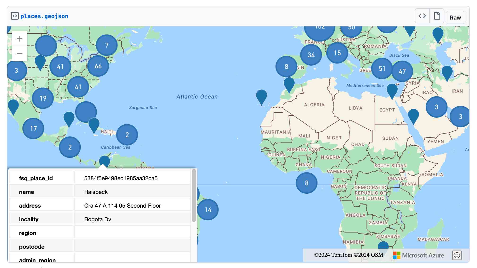
Finally, I got ChatGPT Code Interpreter to convert that file to GeoJSON and pasted the result into this Gist, giving me a map of those thousand places (because Gists automatically render GeoJSON):
A POI Database in One Line (via) Overture maps offer an extraordinarily useful freely licensed databases of POI (point of interest) listings, principally derived from partners such as Facebook and including restaurants, shops, museums and other locations from all around the world.
Their new "overturemaps" Python CLI utility makes it easy to quickly pull subsets of their data... but requires you to provide a bounding box to do so.
Drew Breunig came up with this delightful recipe for fetching data using LLM and gpt-3.5-turbo to fill in those bounding boxes:
overturemaps download --bbox=$(llm 'Give me a bounding box for Alameda, California expressed as only four numbers delineated by commas, with no spaces, longitude preceding latitude.') -f geojsonseq --type=place | geojson-to-sqlite alameda.db places - --nl --pk=id
mapshaper.org (via) It turns out the mapshaper CLI tool for manipulating geospatial data—including converting shapefiles to GeoJSON and back again—also has a web UI that runs the conversions entirely in your browser. If you need to convert between those (and other) formats it’s hard to imagine a more convenient option.
Claude and ChatGPT for ad-hoc sidequests
Here is a short, illustrative example of one of the ways in which I use Claude and ChatGPT on a daily basis.
[... 1,754 words]2023
Geospatial SQL queries in SQLite using TG, sqlite-tg and datasette-sqlite-tg. Alex Garcia built sqlite-tg—a SQLite extension that uses the brand new TG geospatial library to provide a whole suite of custom SQL functions for working with geospatial data.
Here are my notes on trying out his initial alpha releases. The extension already provides tools for converting between GeoJSON, WKT and WKB, plus the all important tg_intersects() function for testing if a polygon or point overlap each other.
It’s pretty useful already. Without any geospatial indexing at all I was still able to get 700ms replies to a brute-force point-in-polygon query against 150MB of GeoJSON timezone boundaries stored as JSON text in a table.
TG: Polygon indexing (via) TG is a brand new geospatial library by Josh Baker, author of the Tile38 in-memory spatial server (kind of a geospatial Redis). TG is written in pure C and delivered as a single C file, reminiscent of the SQLite amalgamation.
TG looks really interesting. It implements almost the exact subset of geospatial functionality that I find most useful: point-in-polygon, intersect, WKT, WKB, and GeoJSON—all with no additional dependencies.
The most interesting thing about it is the way it handles indexing. In this documentation Josh describes two approaches he uses to speeding up point-in-polygon and intersection using a novel approach that goes beyond the usual RTree implementation.
I think this could make the basis of a really useful SQLite extension—a lighter-weight alternative to SpatiaLite.
2022
geoBoundaries. This looks useful: “The world’s largest open, free and research-ready database of political administrative boundaries.” Founded by the geoLab at William & Mary university, and released under a Creative Commons Attribution license that includes a requirement for a citation. File formats offered include shapefiles, GeoJSON and TopoJSON.
2021
Weeknotes: Velma, more Django SQL Dashboard
Matching locations for Vaccinate The States, fun with GeoJSON and more improvements to Django SQL Dashboard.
[... 555 words]country-coder (via) Given a latitude and longitude, how can you tell what country that point sits within? One way is to do a point-in-polygon lookup against a set of country polygons, but this can be tricky: some countries such as New Zealand have extremely complex outlines, even though for this use-case you don’t need the exact shape of the coastline. country-coder solves this with a custom designed 595KB GeoJSON file with detailed land borders but loosely defined ocean borders. It also comes with a wrapper JavaScript library that provides an API for resolving points, plus useful properties on each country with details like telepohen calling codes and emoji flags.
2020
Things I learned about shapefiles building shapefile-to-sqlite
The latest in my series of x-to-sqlite tools is shapefile-to-sqlite. I learned a whole bunch of things about the ESRI shapefile format while building it.
[... 1,073 words]Weeknotes: Shaving yaks for Datasette Cloud
I’ve been shaving a lot of yaks, but I’m finally ready to for other people to start kicking the tires on the MVP of Datasette Cloud.
[... 392 words]geojson-to-sqlite (via) I just put out the first release of geojson-to-sqlite—a CLI tool that can convert GeoJSON files (consisting of a Feature or a set of features in a FeatureCollection) into a table in a SQLite database. If you use the --spatialite option it will initalize the table with SpatiaLite and store the geometries in a spacially indexed geometry field—without that option it stores them as GeoJSON.
2019
togeojson (via) Handy JavaScript library and command-mine tool for converting KML and GPX to GeoJSON, by Tom MacWright
2017
simonepri/geo-maps. Neat project which publishes GeoJSON maps of the world automatically derived from OpenStreetMap. Three variants are available: country political maritime boundaries, country political coastline boundaries and a general outline of the world’s land territories.
2010
Polymaps. Absurdly classy: “a JavaScript library for image- and vector-tiled maps using SVG”. It can pull in image tiles from sources such as OpenStreetMap, then overlay SVG paths specified using GeoJSON. The demos make use of GeoJSON tiles for US states and counties hosted on AppEngine. The library is developed by Stamen and SimpleGeo, and released under a BSD license. SVG support in the browser is required.