57 posts tagged “gis”
2021
Drawing shapes on a map to query a SpatiaLite database (and other weeknotes)
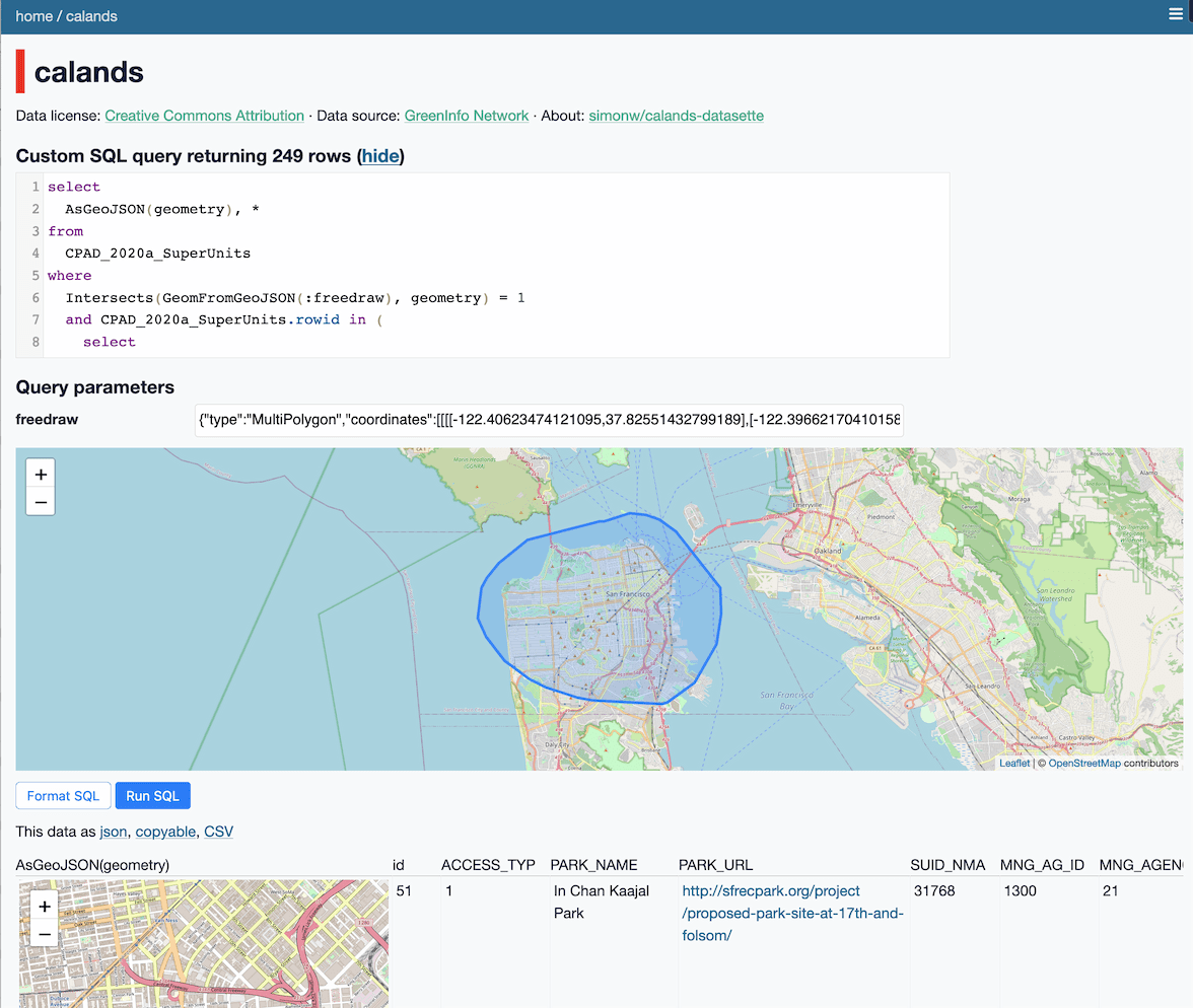
This week I built a Datasette plugin that lets you query a database by drawing shapes on a map!
[... 950 words]Weeknotes: datasette-export-notebook, PyInstaller packaged Datasette, CBSAs
What a terrible week. I’ve found it hard to concentrate on anything substantial. In a mostly futile attempt to distract myself from doomscrolling I’ve mainly been building some experimental output plugins, fiddling with PyInstaller and messing around with shapefiles.
[... 732 words]2020
Weeknotes: California Protected Areas in Datasette
This week I built a geospatial search engine for protected areas in California, shipped datasette-graphql 1.0 and started working towards the next milestone for Datasette Cloud.
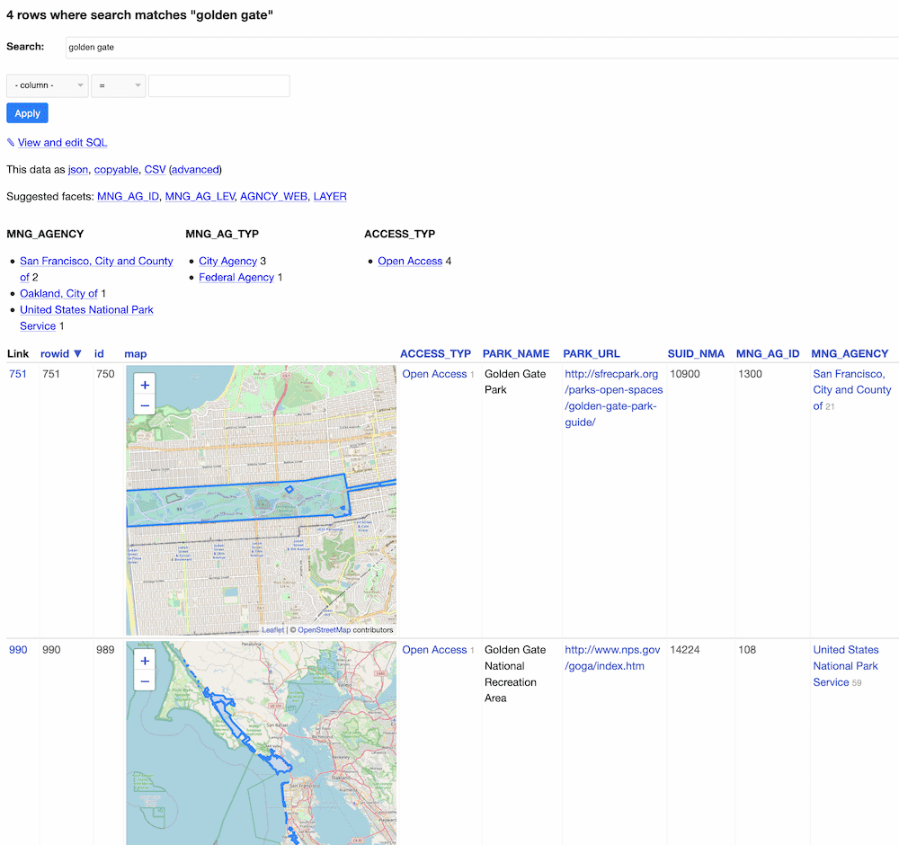
[... 1,099 words]California Protected Areas Database in Datasette (via) I built this yesterday: it’s a Datasette interface on top of the CPAD 2020 GIS database of protected areas in California maintained by GreenInfo Network. This was a useful excuse to build a GitHub Actions flow that builds a SpatiaLite database using my shapefile-to-sqlite tool, and I fixed a few bugs in my datasette-leaflet-geojson plugin as well.
Things I learned about shapefiles building shapefile-to-sqlite
The latest in my series of x-to-sqlite tools is shapefile-to-sqlite. I learned a whole bunch of things about the ESRI shapefile format while building it.
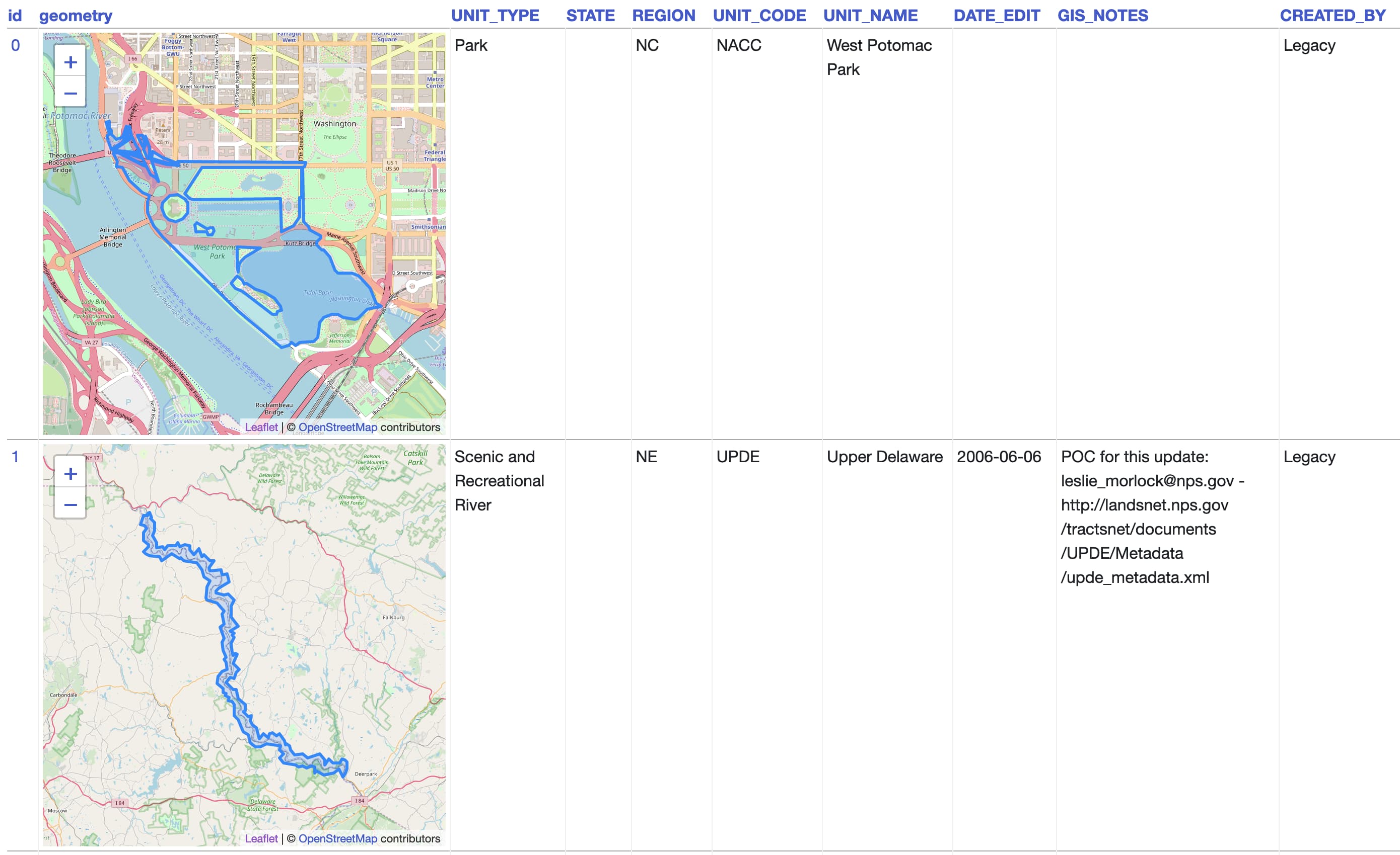
[... 1,073 words]geojson-to-sqlite (via) I just put out the first release of geojson-to-sqlite—a CLI tool that can convert GeoJSON files (consisting of a Feature or a set of features in a FeatureCollection) into a table in a SQLite database. If you use the --spatialite option it will initalize the table with SpatiaLite and store the geometries in a spacially indexed geometry field—without that option it stores them as GeoJSON.
2019
kepler.gl. Uber built this open source geospatial analysis tool for large-scale data sets, and they offer it as a free hosted online tool—just click Get Started on the site. I uploaded two CSV files with 30,000+ latitude/longitude points in them just now and used Kepler to render them as images.
Thematic map—GIS Wiki. This is a really useful wiki full of GIS information, and the coverage of different types of thematic maps is particularly thorough.
Los Angeles Weedmaps analysis (via) Ben Welsh at the LA Times published this Jupyter notebook showing the full working behind a story they published about LA’s black market weed dispensaries. I picked up several useful tricks from it—including how to load points into a geopandas GeoDataFrame (in epsg:4326 aka WGS 84) and how to then join that against the LA Times neighborhoods GeoJSON boundaries file.
2018
VirtualKNN for SpatiaLite. This looks amazing: a special virtual table shipped as part of SpatiaLite 4.4.0 which implements a fast, R-Tree backed mechanism for finding the X nearest points against a geospatial database table. There’s just one catch: it’s only available in 4.4.0, but the most recent “stable” release of SpatiaLite is 4.3.0a from September 2015 so the version you get if you install from apt-get or homebrew doesn’t yet have this functionality. I’d love to figure out a neat way to package and distribute this along with Datasette. I’d also like to figure out a clean way to ship a more recent version of SQLite than the one that is currently packaged with Python 3 (3.16.2, where the latest SQLite release is 3.23.1).
Nicaraguan Address System (via) “Instead of street names or numbers Nicaraguans use reference points from where they start describing a certain address. [...] There are instances, however, in which the reference points do not exist anymore!”
Generating polygon representing a rough 100km circle around latitude/longitude point using Python. A question I posted to the GIS Stack Exchange—I found my own answer using a Python library called geog, then someone else posted a better solution using pyproj.
2017
simonepri/geo-maps. Neat project which publishes GeoJSON maps of the world automatically derived from OpenStreetMap. Three variants are available: country political maritime boundaries, country political coastline boundaries and a general outline of the world’s land territories.
Interactive Database of the World’s River Basins (via) “This database provides the first-ever compilation of the world’s river basins developed specifically for corporate disclosure. It features a comprehensive list of river basins worldwide, including their names, boundaries, and other helpful information.”
Fast GeoSpatial Analysis in Python. Some clever advanced performance tricks with Cython and Dask, but it also introduced me to GeoPandas.
2010
Geospatial Indexing in MongoDB (via) New in version 1.3.3. Handles “order by distance from” queries using a geohash approach under the hood, automatically searching nearby grid squares until the correct number of results have been gathered. Bounding box search is planned for a future release.
On walking into a disaster zone. Schuyler Erle: “The World Bank was looking for technical GIS professionals, ideally French-speaking, to go and advise the government [...] I can sort of speak French. Sure, why not?”
The making of the NYT’s Netflix graphic. A database dump from Netflix, some clever hackery in ArcView GIS, hpricot to scrape Metacritic and a lot of careful thought about the UI for navigating the data.
2009
GeoDjango and the UK postcode database. Excellent introduction to GeoDjango using the recently leaked UK postcode database. Obviously, you should only follow the steps in this tutorial using the officially licensed database, available for a mere £1,700.
openstreetmap genuine advantage. The OpenStreetMap data model (points, ways and relations, all allowing arbitrary key/value tags) is a real thing of beauty—simple to understand but almost infinitely extensible. Mike Migurski’s latest project adds PGP signing to OpenStreetMap, allowing organisations (such as local government) to add a signature to a way (a sequence of points) and a subset of its tags, then write that signature in to a new tag on the object.
OpenStreetMap: QuadTiles. Fascinating explanation of a proposal for replacing lat, lon pairs in the OpenStreetMap database with a QuadTile-based addressing system.
EveryBlock source code released. EveryBlock’s Knight Foundation grant required them to release the source code after two years, under the GPL. Lots of neat Django / PostgreSQL / GIS tricks to be found within.
Yahoo! Placemaker. Really exciting new API from Yahoo!—Placemaker accepts a block of text (or a URL to HTML or RSS) and extracts and returns geographical locations mentioned in the text. I just ran my djng blog entry through it and it pulled out “Prague” as the only location mentioned. This should be really useful for adding geodata to existing textual content.
Yahoo! Geo: Announcing GeoPlanet Data. The Yahoo! WhereOnEarth geographic data set is fantastic, but I’ve always felt slightly uncomfortable about building applications against it in case the API went away. That’s not an issue any more—the entire dataset is now available to download and use under a Creative Commons Attribution license. It’s not entirely clear what the attribution requirements are—do you have to put “data from GeoPlanet” on every page or can you get away with just tucking the attribution away in an “about this site” page? UPDATE: The data doesn’t include latitude/longitude or bounding boxes, which severely reduces its utility.
Google Maps Data API (via) I’m disappointed by this one—it’s really just a CRUD store for the KML files used in Google MyMaps. It would be a lot more useful if it let you perform geospatial calculations against your stored map data using some kind of query API—a cloud service alternative to tools like PostGIS.
2008
Represent. Andrei Scheinkman and Derek Willis describe how they built the NYTimes Represent feature using GeoDjango and PostGIS.
2005
A GIS newsletter describes the server-side tech behind Google Maps (via) Apparently it’s using Telcontar’s Drill Down Server, with extensive customisations.